Friday, January 29, 2010

First "Jelly" at Cohabitat tomorrow!

Tomorrow is the first "jelly" at Shreveport's first shared work space, "Cohabitat," a non-profit organization run by Shreveporter John Grindley, and former Shreveport native and software developer Blake Burris.

The concept of behind places like Cohabitat is to increase the productivity of creative and collaborative work by increasing the connections between similarly and complementarily skilled people. Those connections are created and nurtured by giving them a space where they can work in proximity to one another, and regularly providing forums for presenting work and getting feedback and ideas.

It should be a terrific way to fertilize the ground for creative and collaborative work in Shreveport. Good luck, Cohabitat! We're rooting for you!

"CoHabitat is teaming up with the Columbia Cafe to bring you the area's first coworking "Jelly!" on January 30th @ 10 a.m.

As we're working diligently to get CoHabitat up and running in Shreveport-Bossier, we want to meet and find out a little bit more about you! Whether you're ready to settle down into a coworking community or you just want to learn more about the coworking concept, CoHabitat would like to invite you to come out for our first Jelly, January 30th at Columbia Cafe from 10 a.m. until noon or later.

On the agenda for our first meet up:

- We'll talk about the concept of coworking and the status of bringing the CoHabitat to life in Shreveport-Bossier.
- We'll give anyone who's interested a chance to talk about what what they're working on.
- We'll pick your brain a little bit about what you need from a coworking site.
- We'll finish up with some networking/coworking time, so feel free to bring your laptop and come ready to cowork!

This event is free to anyone who's interested, and the coffee is on CoHabitat!

We hope to make this a regular series of events, so don't miss your chance to be a part of the first!

Want to learn more about CoHabitat? Visit us online at facebook.com/cohabitatshreveport and twitter.com/cohab

What is Jelly?
"Jelly is a casual working event. It's taken place in over a hundred cities where people have come together (in a person's home, a coffee shop, or an office) to work for the day. We provide chairs and sofas, wireless internet, and interesting people to talk to, collaborate with, and bounce ideas off of.

You bring a laptop (or whatever you need to get your work done) and a friendly disposition." (courtesy of workatjelly.com )


John Grindley
318-230-0157 - Mobile
twitter.com/johngrindley

Interested in coworking/shared workspace?
facebook.com/cohabitatshreveport
twitter.com/cohab

Below is are pictures of the future of home Cohabitat on Commerce St. It's a beautiful building inside, parking's easy, and it's near downtown businesses, restaurants, bars, and hip apartments.

Wednesday, January 27, 2010

Green Streets and Stormwater Planters Articles via Tim Wachtel

The following is from Tim Wachtel, a planner for SPAR. Thanks Tim!

I thought that this article was timely. Entitled "Green Streets Pave the Way to Greener Communities" By Jason A. King, ASLA, and Shawn Kummer, it talks about two street projects in Portland and how "green" cuts across many areas of concern, it's not necessarily easy or quick, but it can respond to a wide variety of needs.
If you're not familiar with "stormwater planters," here's a description:
"Stormwater runoff flows downhill along the existing street curb until it reaches the first of four stormwater planters. A 12-inch curb cut channels the street runoff into the first stormwater planter. Once inside the planter, the water is allowed to collect until it reaches a depth of six inches. The landscape system within each planter allows the water to infiltrate in the soil at a rate of four inches per hour. If a rain event is intense enough, water will exit through the planter’s second curb cut, flow back out into the street and eventually enter the next downstream stormwater planter." And another article from Portland:

Monday, January 25, 2010

Trail Blazed from Montessori to Valencia Park!

On Saturday morning Maurice Loridans, Charles Gerrard, Janine Demerath, Jeff Girrard, John Girrard, Feico Kempff, Loren Demerath, John Davenport and Cynthia Keith blazed a trail from Sevier St. by Montessori, through the forest along Anderson Bayou to Valencia Park.

It may be this trail that future generations of Magnet High School students use to bike or walk to school one day, and which many a Shreveporter may use to access the Clyde Fant bike path.

We felt quite productive and proud of ourselves, clearing the trail and marking the way. It may not end up being the exact route used by the greenway we're working towards, but it's a likely start. Next Saturday we plan to plot the route with GPS coordinates and use them to plot the route on a GIS map.

This spring, we will have our second annual Anderson Bayou / Coates Bluff clean up day, perhaps targetting "Tin Can Crossing" as Dr. John Davenport called it. The reason? There are probably several hundred of beer cans and other garbage not far from the bridge pictured here. Many hands will make light the work, as they did on a single day last spring when over 100 people contributed to removing over 3 tons of trash!

Much of the forest is not littered, though, and it is actually a picturesque stretch of woodland and bayou where we can experience nature's beauty in our own city. We plan to request that a gate be created in the fence of Valencia Park's southeastern corner to allow people access to the trail.

Sunday, January 24, 2010

Jon Soul and Larry Raymond walk the Coates Bluff area


Jon Soul, Director of Outdoor Education for the Montessori School for Shreveport and member of ABetterShreveport, walked with Larry Raymond, Director of Parks and Recreation for Caddo Parish, through the beautiful Anderson Bayou and Coates Bluff area last week.

Jon, Larry, and Loren Demerath previewed the route to be established as a trail going from Sevier Street to Valencia Park. Larry noted a wide range of bird species while hiking, as he used the time partly for taking the annual spring inventory.

Along the way, they hiked through the abandoned cemeteries of Coates Bluff, once one of the two primary settlements of what became Shreveport.

Shreveport Times story describes Coates Bluff

Saturday's Shreveport Times contained an article on Coates Bluff and mentioned how ABetterShreveport had been involved. Here's a link to the article by John Andew Prime, and here's an excerpt from it:

"Urban archaeologists trying to improve Shreveport's Red River vantage have stumbled upon interesting traces of the city's past.

Last fall, members of a Better Shreveport, which hopes to create walks and historic pathways through greenways, walked through a heavily wooded area west of the Clyde Fant Memorial Parkway and literally stumbled on crypts and masses of moldering and broken tombstones. The stone sentinels are scattered along gullies in a hilly area historically part of Coates Bluff.

"It's all the way up the hill and down the other side," Jameel Damlouji, president of the Northwes Louisiana Archaeological Society, said after a recent strenuous trek through the site. He is president of the local business Supply America and coordinates with A Better Shreveport. "We're walking through depression after depression after depression, each likely a grave. They're everywhere."

The cemetery fills the woods nestled between E.B. Williams Stoner Hill Elementary Lab School and Caddo Parish Magnet High School.

"It is part of a larger complex of an older settlement, even older than Shreveport," said Gary Joiner, a cartographer and historian who is familiar with the property. "That cemetery sits on top of a bank that goes down to an old steamboat landing. My guess is that in addition to the graves that are marked, there are likely slave graves there that are unmarked."

According to records at the Caddo Assessor's Office, the tract belongs to Caddo Parish Schools and has been called Calvary Cemetery No. 2 and Hopewell Cemetery. City directories from 1925 through the 1950s list the cemetery and its known burials date from 1898 to 1959.

A history published by the Ark-La-Tex Genealogical Association says the cemetery began as a one-acre purchase by the Hopewell Baptist Church, then expanded over the years to more than two acres split into three sections. It was part of a 23-acre tract purchased by Caddo schools in 1949.

Caddo schools Superintendent Gerald Dawkins, who said he's relatively new to the area and isn't personally familiar with the Hopewell Cemetery, said the system started an inventory on its properties in December and hopes to have it ready by the summer."

Tuesday, January 19, 2010

Path making planned for Saturday!

It's time to get outside! But first, notes from last night:

In attendance at last night's meeting were Jeff Girard, Steve Godfrey, Robert Trudeau, Jon Soul, Maurice Loridans, Loren Demerath.

Maurice reported on the degree of bulldozing that had been done at the Riverscape site, and how the greenery that the greenway would've gone through on the last portion of the route has been eliminated. While he was scouting it he ran into Carolyn Manning and mentioned to her that a new route would be appropriate that goes along the school and city side of the fence from Coates Bluff to the north towards Magnet High School.

Jon has talked with Monty Walford about the Coastal Routes grant he is working on. The idea would be to plant native species in a particular area. The planting would take plance largely during a community service and educational day .

Jon is seeking formal permission from the city to use the property around the bayou for educational purposes. Mike Strong has told him to send a him a map of where he's asking about. The group agreed this could be part of getting a foot in the door of that corridor for the greenway.

We discussed two different routes that would be possible. Looking at the Riverscape plat we saw how close the southeastern corner comes to the bike path tunnel. One route could go due east along the back edge of the development, yet through the trees. We could get Riverscape to help us ask for the land to be donated from behind them to the south.

Cecile Coutret said we need to find money to buy the trail land from Riverscape. Or they could donate some and get safe routes to school credit, etc.

Jeff said Coates Bluff qualifies as an abandoned cemetery. It's plotted on the Sanborn Insurance maps (http://sanborn.umi.com; http://sanborn.umi.com/la/3401/dateid-000007.htm?CCSI=3052n) back to 1910 or so. It was the center of a settlement that rivaled Shreve Town. Viking Drive used to be called Hopewell Drive, Jeff thinks. LA GIS has all the GIS data for the state. Very detailed; geo-referenced.

Larry Raymond is going to walk the site with Jon on Thursday at 1:30. Jon's trying to figure out how to break this into bite size pieces. This will help give us a language to use to talk about these things. We need to give Larry a way of talking and thinking about this that gives a way of preserving this. Jeff says it seems to be this would have to be wetlands. Development and what that means is significant; Jeff says it often has to do with "impacts". If there's federal involvement that's probably good in terms of minimizing forest and wetland loss and maximizing how it can benefit our community in terms of quality of life, education, alternative transportation and healthy lifestyles, etc. Jon's going to ask Larry to bring GPS.

The group concluded that we want to ask the city if our path can access Valencia Park, and, perhaps, to ask the parrish school district if the path can access school grounds such as the ball field adjacent to Stoner Hill Lab Elementary, and the track adjacent to Magnet High School. These would be improvements to an existing trail.

To further establish that trail going from Sevier St. north, the group decided that those who can would meet this Saturday morning and clear brush, while plotting the GPS coordinates up to the southeast corner of Valencia Park.

So, we appeal to all of those who'd like to help to meet at the Montessori School parking lot on Sevier St., this Saturday morning at 9:00 a.m. If you can, bring something that could cut brush or sapplings, like loppers or machetes. On Thursday Jon and Loren will be going with Larry Raymond to preview the route.

Davenport lectures on urban morphology in Greenways class

Continuing a blog account of Dr. John Davenport's class, "Greenways, Mobility, and American Public Life," on this day, Dr. John lectured on urban morphology. Here are some notes:

Mid-1900's:
"Accessibility to mobility" is exemplified by land values increasing as you get closer to the rail line, trolley or highway.
1970 to Present:
the satellite community and "jet" epoch

Use of resources increased exponentially, e.g.:
1914 - 14 tons of paper / 1000 people
1985 - 90 tons of paper / 1000 people

Satellite commuter zones with countryside inbetween city and 'burb; also realted to communities locating aside national forests and parks. (Not always good combo when residents complain about natural phenomena like forest fires, wolves, etc.)

(BTW, near rivers are often old "buffalo routes," or are otherwise migration routes for animals generally.)

Axiom of Historical Lumpiness: major change happens in chunks, e.g. invention of cement leading to other significant changes at the same time.

Axiom of Historical Lumpiness: people carry old cultural forms and styles rather than adopting new ones.

Fitting into urban morphology: why greenways now?

Fed Funding has emerged to combat:
congestion and low urban densities
high fuel prices
carbon emissions
obesity

Human Powered Transportation
1/2 of all trips in U.S. could be done in a 20 minute bike ride
1/4 in a 20 minute walk

But doesn't buying cars and building roads drive our economy?
The money would shift into a different industry.

From 1900-1974: a doubling of travel distance; 74-97 double again.

Gentrification is a negative impact for lower income residents.

Earliest greenways in the U.S., e.g., Brooklyn's Prospect Park by landscape architect Frederick Law Olmstead, and provided access to city parks.

Olmstead designed Boston's Emeral Necklace to help drainage. Established multiple uses of greenways.

Benton MacKaye proposes "Open Ways" in early 1900's; (also proposed Appalachian Trail) drawing from network theory.

In 1960's ecology becomes prominent in planning and design. In '69 Ian McHarg publishes "Design with Nature" which incorporates ecological inventories, assessing a landscape, before designing.

An interest in wildlife corridors follows,

Greenways are linear: they are long and provide access for many: high ratio of edge to interior; extends range of animals as well; and humans for transportation.

It begins to be noted that nature is cities too, and something to be planned for, accommodated, and celebrated.

In the 1980's there was a rising popularity in outdoor recreation and interest in open-space conservation spurred many greenways projects.

In 1985 the President's Commission on American Outdoors proposed a national system of greenways: "We have a mission.... fingers of green...."

250 estimated greenways in U.S. in '89, and 3,000 today.

Monday, January 18, 2010

Highland, Stoner Hill, Anderson Island: East Shreveport

Lines in blue in upper middle of map indicate a potential route for a broad pedestrian-bike path to be called the Coates Bluff Greenway.

In the upper right is a corner of the Red River. Parallel to the river is Fant Parkway.

The major North-South highway is Youree Dr.

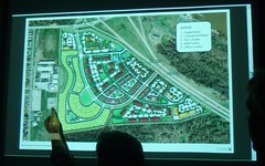
Stoner Ave at Fant Parkway: Riverscape development, Shreveport

From the Riverscape development site: a map showing the current plan for streets and lots.

Running diagonally to the right of the platte blocks is the Fant Parkway.

The hand on the map points to the tennis courts below the Caddo Magnet High complex.

At the top of this view is Stoner Ave.

Friday, January 15, 2010

Agenda for Monday's Greenways meeting

Continuing the every other Monday format of focusing on Greenways, we'll be Greenway focused at this upcoming Monday's meeting. Likely to be some students there from John's course, so let's all behave ourselves, right?

Agenda:
  • Projects for Davenport's students
  • GIS data
  • Beyond Coates Bluff: quick and easy greenway making behind Centenary
  • Publicizing Shreveport Greenways: public service announcements "story boarding"
  • Task list and deadlines